 Tweet
Tweet
Becoming more involved with Scouts lately. Time for a good compass.
Been looking at two different styles:
"Orienteering"
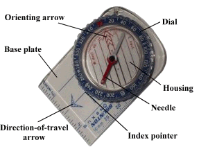
Pros:
Easy to use/follow headings ("point and shoot")
Good with maps
Can easily adjust declination
Relatively inexpensive
Fluid dampened
Small/easy to carry
Cons:
Plastic - not durable
Accuracy (relative)
"Military" (Lensatic)

Pros:
Best accuracy for taking bearings
Metal body - durable
Available with Tritium dials
Copper dampened
Less common -- give kids opportunity to see/learn different types of compass
Learning to use proficiently will make better navigators
"Cool" factor
Cons
Harder to use with maps
Cannot easily adjust for declination
More expensive
Bulkier/heavier than Orienteering style
Slower navigation
Tritium models have limited shelf-life (albeit a long one)
Which one do you recommend and why? Any specific brands/models? I'd like to stay within $100.
Been looking at two different styles:
"Orienteering"
Pros:
Easy to use/follow headings ("point and shoot")
Good with maps
Can easily adjust declination
Relatively inexpensive
Fluid dampened
Small/easy to carry
Cons:
Plastic - not durable
Accuracy (relative)
"Military" (Lensatic)
Pros:
Best accuracy for taking bearings
Metal body - durable
Available with Tritium dials
Copper dampened
Less common -- give kids opportunity to see/learn different types of compass
Learning to use proficiently will make better navigators
"Cool" factor
Cons
Harder to use with maps
Cannot easily adjust for declination
More expensive
Bulkier/heavier than Orienteering style
Slower navigation
Tritium models have limited shelf-life (albeit a long one)
Which one do you recommend and why? Any specific brands/models? I'd like to stay within $100.

Comment